Lucky Leif WI 5+
Blue line
Í mars 2016 fóru Spencer Gray og Eythan Sontag frá Bandaríkjunum nýja leið á suðurhlið Hrútsfjallstinda.
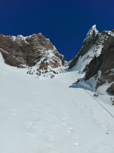
Leiðina klifruðu þeir með áhugaverðum hætti. Félagarnir drógu með sér sleða að suðurhliðinni og gistu þar í tjaldi. Daginn eftir klifruðu þeir þrjár spannir í aðalfossinum í leiðinni sem þeir gráðuðu WI5+, WI5 og WI3. Eftir það bívökuðu þeir félagar áður en þeir kláruðu leiðina næsta dag.
Leiðin er vinstra megin við Scotts leið.
Hér er ferðasaga þeirra frá heimasíðu Ameríska Alpaklúbbsins:
In late March, Eythan Sontag and I (both from the U.S.) climbed a new route on the south face of the east summit of Hrútsfjallstindar (“Ram Mountain,” 1,875m) in Vatnajökull National Park. The Hrútsfjalls peaks are situated on a volcanic crater rim at the edge of one of Europe’s largest glaciers, squeezed between outlet glaciers leading toward the coast.
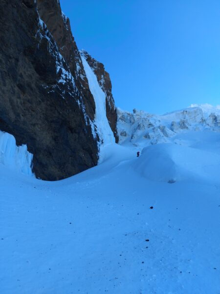
After towing sleds over the five-mile approach up the Svínafell Glacier, with a heavily crevassed lower half, we dug out a camp under the face and away from an active icefall. The three-pound chocolate Easter chick we had recruited as our base camp sentry didn’t survive the crossing. We glumly ate her, brooding that we’d just killed an albatross.
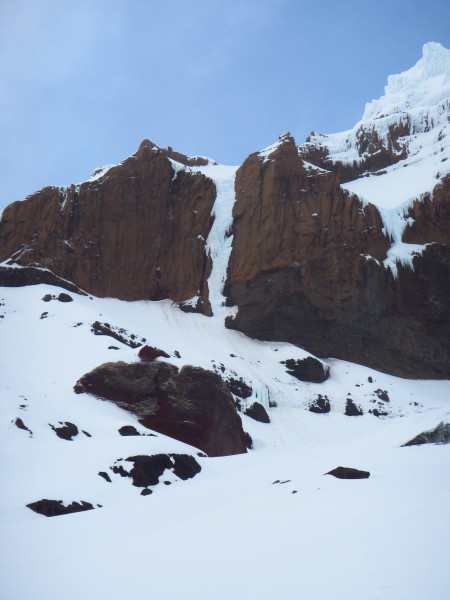
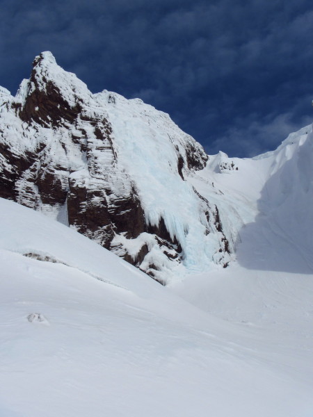
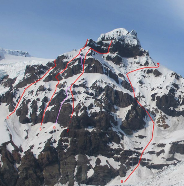
The south face has four steep snowfields separated by three overhanging basalt cliff bands. (The total vertical gain from the glacier to the summit is approximately 1,400m, of which the steep, technical headwall comprises about half.) Ice flows connect the snowfields and allow passage through the cliffs. There are now at least four technical routes up this aspect of Hrútsfjallstindar and several others on the western summit. In good conditions, there are at least a dozen long ice lines in the immediate vicinity with no reported ascents.
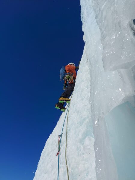
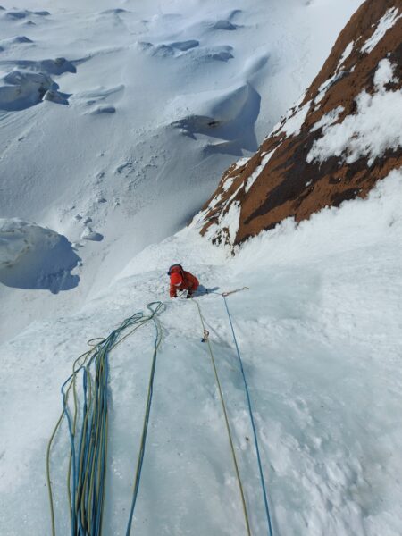
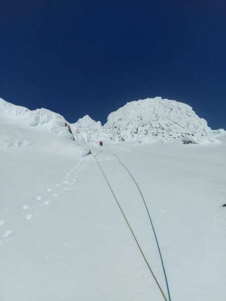
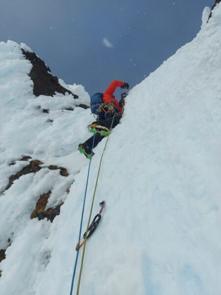
We began our new route on March 29, taking the leftmost ice line (three short pitches: WI5+, WI5, WI3) through the first cliff band. The lower 20 feet of ice had broken away, leaving the technical crux right off the deck: a mixed start up to an ice roof. (From past pictures, this seems to be a common condition. Also, given the relatively easy access to the first cliff band, it wouldn’t be surprising if this first pitch had been climbed before.) We hauled packs through this initial section and bivied comfortably before dark at the second cliff band. Eight inches of new snow over the course of the day caused steady but shallow sloughing into the night. The rock took occasional solid knifeblades and angles, and we were glad to have pickets. The ice protection deteriorated steadily as we moved up the mountain, ending in degraded Styrofoam and janky rime that made the technically easier pitches the spicy ones.
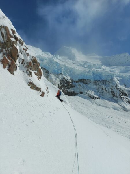
On day two we continued up a variation (two pitches: WI4, WI3) to the right of the 1985 Doug Scott line (the first technical route up the face—see editor’s note below) through the second cliff band, followed by more steep snow and then a delicate winding traverse (two pitches: WI5, WI3) up the center of the final cliff band. This finish is between the final cockscomb buttress of the Scott line and a 2000 route (“Porcelain”). We yanked over the final rampart with a premonition of arrival, as if we had slipped through an embrasure separating us from something we hadn’t known we were after. Perhaps Asgard was floating just ahead.
The summit glacier was easy walking, with crevasses mostly plugged. Into the evening, the sun tracked just behind a thin cloud, an eye of Sauron beaming yellow and then pink down the western slopes. We downclimbed for several hours to climber’s left of the seracs southwest of the west summit, keeping a wary eye out for glacial sinkholes and flowing waterfalls in the lower drainage.
 |
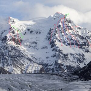
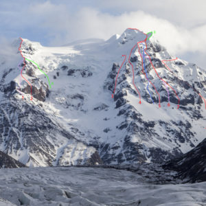
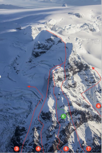
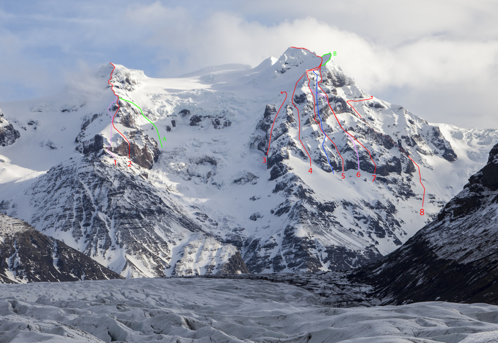
| The western (left) and eastern summits of Hrútsfjallstindar (1,875m) from the south. (1) (Geirsson-Guðmundsson, 1986). (2) Smjörfingur (Meucci-Ólafsson, 2015). (3) 10 Norskar Stelpur (Meucci-Ólafsson, 2015). (4) Friðriksdóttir-Hjaltason-Steingrímsson, 1981. (5) Lucky Leif (Gray-Sontag, 2016). (6) Scott’s Route (Benediktsson-Geirsson-Guðmundsson-Guðjón-Scott, 1985). (7) Íshröngl (Björnsson-Steingrímsson, 2012. The climbers traversed left to join the Scott Route above the second rock band). (8) Postulínsleið (Finnbogason- Þorgeirsson-Sigurðsson, 2000). (9) Stóragil (Benidiktsson-Guðbjartsson, 1983). Route information courtesy of Ísalp. Photo by Spencer Gray |
We called our new route Lucky Leif (TD WI5+ M4). Leif “the Lucky” Erikson was an Icelandic Viking who established what was probably the first European settlement in the Americas, in the year 1000, in Newfoundland. Making the reverse trip, we felt lucky that conditions had allowed our ascent.
After 10 days trying to tap into our inner Old Norse, we still felt like rubes—but we certainly had held Iceland in our hands. Vatnajökull National Park was expanded and renamed in 2008, partially offsetting political fallout from the staunch government support for the new hydroelectric dams and reservoirs nearby that power a large smelter for aluminum exports. Clutching the aluminum that lets us do what we do—tool shafts, belay devices, carabiners—our adventure occurred squarely in the compromises we make on the land.
Our deep appreciation to Snævarr Guðmundsson and the Icelandic Alpine Club for their assistance.
Spencer Gray, USA
Editor’s note: The south face of Hrútsfjallstindar’s eastern summit was first climbed by Icelandic parties in the early 1980s, taking snow gullies up the left side (PD) and right side of the face. In May 1985, Doug Scott (U.K.) and Icelandic climbers Helgi Benediktsson, Jón Geirsson, Snævarr Guðmundsson, and Þorsteinn Guðjón climbed the first technical route through the steep rock bands, with ice pitches of WI5 and WI6 and a final rime “cockscomb” with very poor protection and belays. Three more lines were completed before the 2016 ascent: Postulínsleið (“Porcelain,” TD WI5, 2000) and Íshröngl (TD WI4/5, 2012, combining variations to Porcelain and the Scott route), both by Icelandic climbers, and a line climbed by a large French party in 2007, also combining portions of the Scott and Icelandic routes. Given the nature of the face, it’s likely that any ascent will include some previously climbed ground.
The direct south face of the western summit of Hrútsfjallstindar was first climbed in 1986. In 2007, French climbers did a possible new route on the face, but the exact line is not known. In April 2015, Bjartur Ólafsson (Iceland) and Matteo Meucci, an Italian guide working in Iceland, climbed Smjörfingur (“Butter Fingers,” TD AI5) up the west peak in 19 pitches, beginning with a very steep 110m icefall. The day before, the same pair climbed a steep route on the far left side of the eastern peak, 10 Norskar Stelpur (“Ten Norwegian Girls,” TD AI4) without going to the summit.
http://publications.americanalpineclub.org/articles/13201213869/Hrtsfjallstindar-South-Face-of-East-Peak-Lucky-Leif
| Crag | Öræfajökull |
| Sector | Hrútsfjallstindar |
| Type | Ice Climbing |
| Markings |